Death Valley National Park

June 12, 2017


A very unique hottest, driest national park in the United States with unique geographical feature and views changing every one mile. A trip to Death Valley national park will require a little of preparation as it is difficult to find fuel station, food, signal inside the national park.

Tips to visit the park:

Decide if you are just going to drive through the National Park visiting as a day trip visiting the highlights or you are interested in spending two days and cover the park of the park.

Stop at the visitor center and plan your day to get an idea of the day's road closure, alerts, get a brief idea about the points of interest you wish to cover

Important: Download Google offline map or carry car GPS, beyond the visitor center there is no cell phone signal for the rest of your drive into the park.

Keep enough water, snacks, and some packed food in your car, well its a desert.

Keep yourself hydrated and increase the amount of water intake for a few days before the visit just as to ensure you do not get dehydrated on your trip.

The temperature will be soaring high, dress appropriately.

There is an accommodation/lodge inside the national park, decide if you wish to stay there. They got interesting star gazing activity. Remember Death Valley National Park is a great place to see galaxy on a clear sky day.

The sun was really bad on the passenger seat. I covered my passenger side with a paper if you have a sun shield or something it's worth carrying along on your trip.

Carry portable battery charger, first aid kit, car tools, spare tires for an emergency.

Carry sunscreen.

Do fill fuel tank in Ridgecrest, you will find a couple of fuel stations inside the park but they will be pretty expensive, however, given the location.

Carry instant ice packs, to tap it on yourself and to cover and tap water bottles. Bottles in the car gets really warm through the day

Here is a brief about or trip

Day one: We started from, Los Angeles, early and reached by around 10.30 AM. The sun had already started treating us bad. As we entered from, Los Angeles, our first palace where we could pay our fee was Stovepipe Wells Ranger Station, we paid the park entry fee and picked up a map from the place (ensure you pick up the map, as it comes handy even if gadgets fail to assist). 

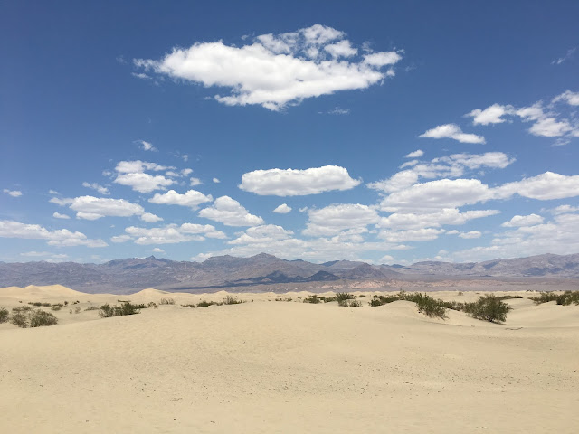
The first point of attraction we stopped was Mesquite Flat Sand Dunes, The largest dune field in the park.  This dune field includes three types of dunes: crescent, linear, and star shaped. 

Mesquite Flat Sand Dunes


Our next point of Interest was Ubehebe Crater  The crater can easily be view by walking around .3 miles from the parking lot. The walk is graveled and steep. So good shoes are recommended. we did a small walk around the rim of one and a half miles.

                                                                Ubehebe Crater


The crater was magnificent to look at. We skipped Titus Canyon as a high clearance vehicle is required. Next, we headed for lunch to Furnace creek, on our selected route and on the road that goes towards Las vegas this is the only place where you can find food.

After lunch, we headed to Zabriskie Point, most famous view point overlooking badlands and a popular view for Sunrise and Sunset, which you can give it a shot if you stay at the Furnace creek lodge. 

 Zabriskie Point
Next, we drove through twenty mule team canyon road, a 2.7 miles loop, where we could see salt visibly in-between the rock/ canyon sides, very unique of its kind. A canyon which has a lot of history to it.

Twenty mule team canyon

To end our site seeing for the day, we visited our last point of interest, Dante's viewpoint. Again it's very unique as to gives a view of the lowest point in North America, Badwater Basin and the highest point in the contiguous United States, Mount Whitney in California something to note is the peak is not visible. This is a famous sunrise point in the park.
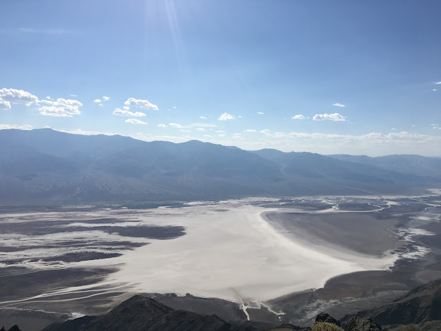
Dante's viewpoint

We decided to stay in Ridgecrest, we had to head back to our hotel immediately. Exiting the park before Sunset is always the best option.

The long straight, never-ending roads of the park 

Day two: Next day morning we headed first to the Devils Golf Course, where you can see rock salt which is sarcastically quoted as only devils can play golf. Well, pay attention you can hear salt cracking. To listen to this you need to get your ears close to the ground and pay attention. It's once again unique and fun.
Sharp edges formed by the salt

Devils Golf Course


Next, we headed to the interesting point, the lowest point in North America Badwater Basin, 282 feet below sea level. Visitors are requested to stay on the trail to protect snail living in there. 


The distance from parking lot to the attraction was less than .2 miles, we spent around 15 min at the basin. We consumed around a liter of water each. We felt the heat and were getting thirsty. 

Before exiting the park and as the last point of interest we visit Artist drive loop, a 9-mile road where you get to drive through multi-colored volcanic rocks and sediments. You can spot green, red, yellow color on the rock that its named artist palette.


After visiting the park we exited through road no. 190 and drove towards Las Vegas.

Antelope Canyon

May 31, 2017
Antelope Canyon is divided into the upper and the is lower Antelope Canyon.

Cost: Tours to the lower canyon costs around $35 per person and upper canyon costs around $45 per person which includes, entry to the antelope canyon and entry fee to Navajo country.There are no combination/concessional tickets for both upper and lower canyon. We should buy the tickets individually. Photography tour, which is designated only for professional photographers costs around $145.

Time to visit: Best time in the day to visit the canyon is when the sun is at its peak around 12.00 PM to 1.45 PM. Entry tickets at peak hour is $10 more than the regular prices. Tickets for this time slot tend to get sold quickly. We were lucky to get 1.15 PM tour slot.

Also, please know that the tours are scheduled to be canceled if there is a flash flood alert.

As the path in the canyon is tight there is no wheelchair accessibility and small children are not allowed ( only in the lower canyon). The canyon is the sacred place for the tribes. Hence its advised to treat the canyon with respect.

We were been asked to assemble at the tourist office 15 minutes prior to the departures time. We were divided into groups of 15 to 20 headed by one tour guide. At 1.15 PM slot, there were around five groups which departed from our tourist location. Also, please be aware that we cannot drive our private vehicle till the entrance of the canyon. The tour company takes us up and down to the canyon. Which means the tour starts at the tourist office and ends at the tourist office. The distance from the tourist office to the canyon is around 15 minutes drive. At the end of the tour, tips are appreciated by the guide.

The drive to the canyon is on a sandy unpaved road more like sand dunes.

Antelope Canyon

The picture below shows the entrance to the canyon. As I mentioned the path to the canyon is tight. Tour enters in one line, one direction and exists in the other direction. In the picture, we can clearly how the canyon was cut by the flash flood and of course the views inside again proves, nature is the best artist.

Entrance of the canyon
You tour guide will point out at the various place inside the canyon and what it depicts. They even assist you to capture pictures of the canyon.

Inside the canyon

     
If we closely observe sides of the canyon, we can get the feel how the water would have flown gushing through. When the lights penetrate through the canyon, it reflects vibrant colors.


Our experience about the trip: It was a very beautiful place to be in. We would vouch for its uniqueness and beauty. However, we were a little disappointed with the way the tour was organized.

1) Too many people inside the canyon, making the place congested.
2) Our tour guide would point out to a particular place inside the canyon and say, "stand here focus your camera to this point you will be able to see a dolphin, George Washington's face" etc;. It's a canyon any person can associate the formation as per his thoughts. It's just like looking at the cloud and telling it looks like a man's face while other will end up telling it looks like a girls face and the third person ends up telling I am unable to figure out anything.
3) When the tour guide points out to take picture of something our co-tourist used to push, come in front of our camera to take their picture. Totally inconsiderate. How nice will it be if each one of us took our turns? We didn't like the feel of people pushing into us. We ended up lining up last in the line in the batch of 15 people.
4) As we ended up being the last in the line we could listen to what our tour guide described and what the tour guide behind us describes. It was funny at the point where our tour guide describes as George Washington's face and the one behind describes as Abraham Lincoln's face. This is just an example and this happened multiple time. They were not consistent with the tour description.
5) Finally, there was no  useful information at the end of the tour like
a) geographical details
b) specialty of the canyon
c) anything about the flash flood
d) scientific details of the fine sand that you can find on the ground (walkway) not even
e) a short introduction about their tribal community, why the canyon is sacred to them. When I asked my tour guide. "Are prayers performed even today by the Navajo residents?" she replied. I am not sure but I guess not.

We paid $45 just to enter the canyon and walk around. Do you want to spend so much? or not? the ball is your court.

I would say its a beautiful place but not worth $45 after the tour, we decided not to take the tour of the lower canyon. We were just happy with one tour.

Glen Canyon Dam:

After visiting the canyon we headed to Glen Canyon Dam and took the guided tour of the dam for $5, they will take way to the generator room (which is down in the dam ) talk about the history, construction, maintenance etc.,


Generator room
From the bottom of the dam, focusing up the visitor center (the circular building that you can spot)


 Tour of the dam was great. We had a few kids in the tour, who enjoyed it the most.


After the tour, we headed to our campsite at the Powell Lake campground.

Road Trip Canada : Sea To Sky Highway

May 29, 2017


Sea To Sky Highway


Why not, explore an exciting drive with beautiful sceneries from deep blue sea, waterfalls, chilling beach to snow-capped mountains...?, yes, obviously we are suggesting about the most scenic drive in Western Canada "Sea to Sky Highway".

Our description of "Sea to Sky Highway":


A perfect road trip for an international vacation, for traveler's living in the Washington State, USA . 

The drive is loaded up with beautiful viewpoints making it an ideal for travelers of all ages.

There are several viewpoints for every 15 minutes in the drive. If you are an exercise or a yoga lover, book lover, artist or a  writer. The drive opens up beautiful viewpoints to immerse into the beauty of nature and concentrate on your passion.

Saving the best for last, Sea to Sky highway offers a spectacular drive for motorists, bikers, and racers.

Where is Sea to Sky highway:


The Sea to Sky Highway is the name given to a section of Highway 99, which begins near Horseshoe Bay on the outskirts of Vancouver, B.C. You can Reach it via the Trans Canada Highway 1 and ends at Pemberton where the road becomes Duffy Lake Road. 

Road conditions:

It's always a great option to check the road conditions before you head for the drive, visit the official website, www.drivebc.ca or call 800-550-4997. As mentioned this will be an international vacation which requires border crossing. Visit www.getyouhome.gov for documentation about the border crossing.

Top Attractions along the drive:


You will get a lot of suggestions for the points of interest along the drive.

The Super Natural British Columbia website has shortlisted a few and link to their website is here.  In the website, you can also find numerous outdoor adventure sports that you can do during your drive. Sea to Sky Gondola is one of the major attraction in this route. The Gondola gives you an eagle eye view of the
Whistler areas.


In the below-embedded map, you can find the major points of Interest along the Sea to Sky highway which we have shortlisted. Along the route, there is a beautiful lake, breathtaking waterfalls and lookout points.


There are two native group in this region, the Squamish, and Lil'wat First Nations. A short stop by First Nations kiosks will help us get an introduction to the region, through which we will be driving for the rest of the day and a brief idea about the everyday life of the tribes. You can also visit their website, https://slcc.ca  to get an idea about the place, operational hours etc,.


Starting the Drive: 


The drive starts at Horseshoe Bay and goes around Howe Sound.


The sound is triangular shaped, open on its southeast towards the Strait of Georgia, and extends 42 kilometers to its head at Squamish. There are several islands in the sound, three of which are large and mountainous in their own right. Our first stop will be 14.2 km from Horseshoe Bay, Brunswick Beach Park, Lions Bay will give a great view of the Howe Sound.


Porteau Cove Provincial Park


Our next stop along the way is  Porteau Cove Provincial Park, which is 11.8 km drive and takes around 19 minutes.  The park again offers a view of the Howe Sound with the mountains in the backdrop.


Our next stop about 8 km away will be Britannia Mine Museum, the offer guided tours of the mining areas. To know more about tour timing and  guidelines for kids under the age of three, visit the website at http://www.britanniaminemuseum.ca/hours-and-tour-times


Our next stop along the drive will be 7.5 km away, Shanon falls it is composed of a series of cliffs. This is the third highest falls in British Columbia rising 335 meters above Highway 99. Visit website link http://www.env.gov.bc.ca/bcparks/explore/parkpgs/shannon/ for reservation and activities that you can do at the park.


Stawamus Chief


Our next stop will be ahead at 3.5 km at Stawamus Chief, which is considered as one of the largest granite monoliths in the world and its sheer rock face dominates the view from the highway.


Our next stop is just 3.4 km away at Squamish, considered as the“Outdoor Recreation Capital of Canada,”. To explore various outdoor recreational activities visit http://www.exploresquamish.com


Three Optional Points of interest along the drive:


Brackendale is home to one of the highest concentrations of wintering bald eagles in North America. If you are driving between November and  February, ensure to stop at Brackendale Eagle provincial park, for eagl watching to see Eagle feeding on the Salmon. This park is 9 Km away from Squamish.


In 12.5 Km drive from Brackendale Eagle provincial park, there is a breathtaking panoramic view of the Mt. Tantalus. You can choose to stop at this point on your return journey as the pull over for the look out point will be when your drive towards Vancouver. You can choose to observe it as a drive though or pull over and view. Either way, do not miss the view. On a clear day, the mountains reflect. Violet, blue, green, snow-capped white.


Mt. Tantalus


In next 32 km from Mt. Tantalus lookout point. The next point of interest is one of the most celebrated hikes and the lake of Canada. Yes, the Garibaldi Lake. Visit website http://www.env.gov.bc.ca/bcparks/explore/parkpgs/garibaldi/ for trail conditions and campground reservations. The drive to the trailhead is around 30 km away.


Brandywine Falls Provincial Park


In next 40 km drive from Squamish, you will reach Brandywine Falls Provincial Parkwhich plummets straight down for 70 meters (230 feet). The lookout points adds more interest to the park itself from where one can see Daisy Lake and the distinctive Black Tusk mountain peak in the distance.


Do take a picture at the railway track while walking to visit the Brandywine Falls Provincial Park


View of Daisy Lake and the distinctive Black Tusk from Brandywine Falls.


Heading further 18 km on the highway you will reach, Whistler. Its world famous location for winter sport. Whistler became even more world-renowned as the site of the alpine and Nordic venues for the Vancouver 2010 Olympic and Paralympic Winter Games.


Whistler Village


To end the Sea to Sky highway drive, at 29 km,  you will finally reach Nairn Falls Provincial Park.  The falls 60 m high and a 1.5 km hiking trail will take you to the viewpoint.  Nairn Falls is a dramatic example of the erosive power of water. Look for “potholes” created in the rocks as the water spins trapped particles in ever-deepening circles. 


Pic:1 - View of the Falls 


Pic:2 - History


Pic:3 - Notice potholes

Tips for your visit:


It's a perfect "weekend getaway" or a "long weekend getaway",  road trip from Seattle. Camping is a perfect option for the trip there are a lot of campsites available across the drive and provincial park


Capilano Suspension Bridge is one of the most famous bridges in the areas. Undoubtedly it will be one of the beautiful walks of your lifetime and obviously the most expensive one of $45. Alternately, I suggest you visit  Lynn Canyon Suspension Bridge which will give you a similar experience for free of cost, though shorter than the former lengthwise and heightwise.


Reaching Lynn Canyon Suspension Bridge from Portland Downtown:


View of the bridge.
The view of the forest and the greenish water flowing below.
Have a great drive along the Sea to Sky Highway.

West Coast Road Trip - Seattle to San Diego

May 27, 2017

Unedited sunset at the Oregon Coast.


In this section, I am going to cover about a road trip from Seattle to San Diego through the beautiful West coast, considered to be the most scenic drive of the USA. 

Things to consider before booking your ticket:
1) Duration of the vacation
2) Am I booking the flight and car rental as a multi-stop or round trip? 
3) Will I be jet lagged on reaching Seattle

The itinerary below is customized for the number of days of vacation you are interested in taking, The trip works out well with multi-stop ticket (Fly into Washington state and fly out of California State )However, for the readers who decide a round trip ticket with shorter vacation, your suggestion can be found in the Last column in the below tabular column of Notes.

The landscape:
In the suggested itinerary, you will visit through famous National parks of the USA, breathtaking waterfalls, hike a volcanic mountain tube, a beautiful coastal area with jaw-dropping sunset and sunrise to enjoy.


StatesFamous National Parks
WashingtonMt. Rainer, Olympic National.
OregonCrater Lake.
CaliforniaRedwood, Channel Island.


Vacation durationFour daysOne weekOne and half weekTwo weekTwo and Half weekNotes
Day One:                     Early morning,Land in SeattleLand in SeattleLand in SeattleLand in SeattleLand in SeattlePick the rental car and head to Seattle downtown.

Explore downtown. Book hotel in Tacoma for the night.Explore downtown. Book hotel in Tacoma for the night.Explore downtown. Book hotel in Tacoma for the night.Explore downtown. Book hotel in Tacoma for the night.Explore downtown. Book hotel in Tacoma for the night.If you will be jet lagged end your day early.
Day Two: Start early, one and half hour drive timeDrive to Mt. Rainier National Park.Drive to Olympic National ParkDrive to Olympic National ParkDrive to Olympic National ParkDrive to Olympic National ParkNote for Four days round trip ticket readers: Drive the scenic loop in Mt. Rainier national park

Explore the park.Explore, Olympic National ParkExplore, Olympic National ParkExplore, Olympic National ParkExplore, Olympic National Park

Day Three:Start early, head towards, Oregon. Drive time four hours.Explore, Olympic National ParkExplore, Olympic National ParkExplore, Olympic National ParkExplore, Olympic National Park


Explore Columbia River George National Scenic Area and return to Portland downtown for the night.Go for a hike.Go for a hike.Explore, Olympic National Park in the evening head towards Mt. Rainier National Park for the night. Book hotel in Olympia. Drive time three hours.Explore, Olympic National Park and head towards Mt. Rainier National Park for the night. Book hotel in the park.

Day FourExplore Portland downtown and garden of your choice.Drive Highway 101 and reach Thor’s well, drive time eight-hour driveIn the morning, drive Drive to Cannon beach, drive time four-hoursDrive to Mt. Rainier national park. Drive time two hours. Drive the scenic loop in Mt. Rainier national park.Drive the scenic loop in Mt. Rainier national park.Note for Four days round trip ticket readers: Start Heading back to Seattle by 4.30 PM for the late night flight scheduled after 10.00 PM and return rental at the airport location.

Explore Portland downtown and garden of your choice.  Take the late night flight back home from Portland.Enjoy the coastal area and stay around Thor’s well for the night.Stay along the coast for the night.Stay in and around the park for the nightStay in and around the park for the night

Day Five:

Start early, head towards Crater lake National Park, drive time four hours.In the morning head towards Columbia River George National Scenic Area. Drive time two and half hours.Drive to Ape cave, for lava tube hike in Mt. St Helens. Drive time three hoursApe cave hike in Mt. St HelensNote for One week round trip ticket readers: Skip Crater Lake National Park and do as directed in Day six


Explore the park and stay around the area for the night.Head towards Portland. Book hotel in this area for the night.Drive to Cannon beach for sunset, and stay for the night Drive time three and half hour.Drive to Cannon beach, and stay for the night four-hour drive

Day Six

Head towards Columbia River George National Scenic Area, drive time five hours drive.Explore downtown, the garden of your choice, brewery.Enjoy the coastal area and head towards Columbia River George National Scenic Area. Drive time two and half hoursEnjoy the coastal area and head towards Columbia River George National Scenic Area. Book hotel in this area for night stay.Note for One week round trip ticket readers: Follow day seven


Enjoy the scenic drive. Stay in the area or drive to downtown for the night stay.Drive and stay in Albany/ Salem for the night. Drive time one and half hour.Book hotel in this area for night stay.Start early and head to Portland.

Day Seven

Start early, explore downtown, gardens, brewery. Take Late night flight back home from Portland.Head towards to Thor’s well, drive time two and half hours.                  Next head towards Redwood National Forest along Highway 101.        Stay in an appropriate location on the way if you want or reach Redwood National Forest.Start early and head to Portland. Explore Portland downtown, gardens, brewery. Drive time to downtown, thirty minutes. Explore Portland downtown, gardens, brewery.Note for One week round trip ticket readers: Start Heading back to Seattle by 4.30 PM for the late night flight scheduled after 10.00 PM and return rental at the airport location.


In the evening drive and stay in Albany/ Salem for the night stay. Drive time one hour. Drive and stay in Albany / Salem for the night stay.

Day Eight


Explore the National Park.In the morning, start early and drive to Thor’s well, drive time two and half hours.Drive to Thor’s well, drive time two and half hours. Next head towards Crater Lake National Forest.


Head towards Redwood National Forest along highway 101. Drive time six hours.


Day Nine


Morning Drive towards San Francisco. Along Highway 101. Drive time Seven Hours.Start Early and explore the National ParkStart Early and explore National Park and head towards Oregon CaveNote for One and half week round trip ticket readers: Start early in the morning and head to Napa Valley for wine tasting. Drive time five hours.


Break the drive in between if required

Head towards Redwood National Forest

Day Ten


Explore San FranciscoStart early and head towards Napa Valley Along Highway 101 for wine tasting. Drive time five HoursStart Early and explore National ParkNote for One and half week round trip ticket readers: Visit the Oregon Caves National Monument along highway 199. Drive time two hours. After the visit, continue driving near Mt.St Helens area for staying the night.


Stay in the park for the night

Day Eleven


Explore San Francisco and head to the airport for the journey back homeHead towards San FranciscoStart early and head towards Napa Valley Along Highway 101, for wine tasting. Drive time five HoursNote for One and half week round trip ticket readers: Start early and hike the ape cave (lava tube) at Mt. St Helens. Start driving back to Seattle for the late night flight back home. Drive time three and half hours.


Explore San Francisco


Day Twelve


Drive towards Los Angeles, Stay in an appropriate location on the way if you want or reach Los AngelesHead towards San Francisco, explore the city.Note for two weeks round trip ticket readers: Start heading back towards Oregon early in the morning. drive up to Grand Pass in Oregon. Drive time seven hours


Explore Los Angeles


Day Thirteen


Drive towards Los Angeles, Stay in an appropriate location on the way if you want or reach Los AngelesNote for two weeks round trip ticket readers: Visit the Oregon Caves National Monument along highway 199.


Explore Los Angeles and head to airport for journey back homeExplore Los Angeles

Day Fourteen


Explore Los Angeles

Day Fifteen


Explore Los Angeles

Day Sixteen


Explore Los Angeles, and drive towards San Diego

Day Seventeen


Book late night flight out from San Diego to back home.


Powered by Blogger.